
Covered Bridges
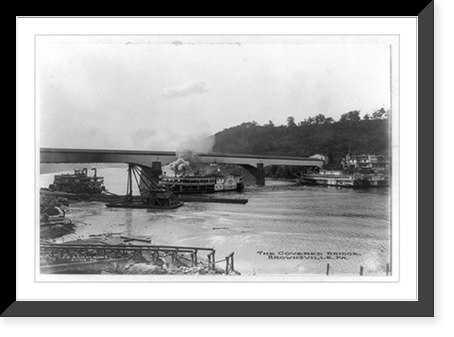
The roof was never for travelers. It was there to keep rain off the trusses.
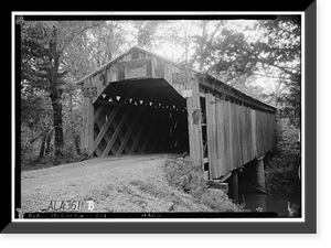
An untreated timber bridge left open to the weather rots at the joints within about ten years. Cover it and the same timbers last eighty or a hundred. That is the entire explanation, and it is why the bridges are enclosed on the sides as well as the top, often with only a small window cut so a driver could see a boat coming.
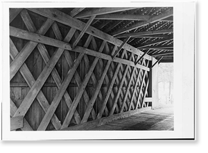
The engineering underneath is more interesting than the picturesque exterior suggests. Three patented systems account for most of what survives. Theodore Burr’s arch, patented in 1817, combines a timber arch with a truss so the two carry the load together. Ithiel Town’s lattice, patented in 1820, is a criss-cross web of light planks pinned with wooden pegs — it required no heavy timber and no skilled joinery, and a local carpenter could build one from a licensed plan. William Howe’s truss of 1840 introduced iron rods for the vertical members and became the standard for railroad bridges.
Town charged a license fee per foot of bridge, which made him one of the first Americans to earn a real living from a structural patent.
Most of these were toll bridges, privately financed by companies chartered to recover their cost from traffic. A tollhouse at one end and a posted schedule — so much for a horse and rider, so much per head of cattle, so much for a loaded wagon — are common in the photographs. Counties bought them out gradually through the later nineteenth century.
The kissing bridge business is real but overstated. A covered bridge is dark, and a horse slows down going into one, and courting couples noticed. The name shows up in period writing. It was a minor folk custom, not the reason anybody built anything.
Something like fourteen thousand were built in the United States, and fewer than a thousand remain. They came down for ordinary reasons: floods took them, fires took them, and above all the trucks got heavier than the trusses. A bridge designed for a loaded hay wagon could not carry a 1940s truck, so counties replaced them with steel and concrete as fast as budgets allowed.
That is why so much of the photography is from the 1930s and 1940s. The Historic American Buildings Survey sent people out during the Depression to measure and photograph structures that were disappearing, and covered bridges were high on the list. Those photographs were made as records of things about to be lost, and in most cases they were right.
They cluster geographically, and the pattern is about timber and water. Pennsylvania, Ohio, Indiana, Vermont and New Hampshire hold most of the survivors, because those states had the hardwood, the streams that needed crossing, and the mill economy that put a bridge at nearly every mill. The bridge and the mill appear in the same photograph often enough that finding one usually means looking for the other.
For captions, the portal is the identifier. The shape of the opening, the trim boards and the painted lettering across the entrance are usually the fastest way to match a photograph to a named bridge.
The Store Was Also the Post Office




-

 Snapshots of the Past
Vintage Building Photo - Ashland, Delaware - Covered Bridge (3)
Originally preserved in the Library of Congress, this print of Ashland Covered Bridge, Red Clay Creek-Barley Mill Road, Ashland, New Castle County, DE - 3 is now available for your home or office...$57.00 -
 Snapshots of the Past
Vintage Building Photo - Ashland, Delaware - Covered Bridge (2)
This rare historical print captures Ashland Covered Bridge, Red Clay Creek-Barley Mill Road, Ashland, New Castle County, DE - 2 in remarkable detail. Sourced directly from the Library of Congress, it...$57.00 -
 Snapshots of the Past
Vintage Building Photo - Ashland, Delaware - Covered Bridge (1)
Drawn from the Library of Congress archive, this print depicts Ashland Covered Bridge, Red Clay Creek-Barley Mill Road, Ashland, New Castle County, DE. The Library holds one of the most comprehensive...$57.00 -
 Snapshots of the Past
Vintage Building Photo - Cherokee vicinity, Alabama - Buzzard Roost Cove
Drawn from the Library of Congress archive, this print depicts Buzzard Roost Covered Bridge, Highway to Allsboro Southwest of Cherokee, Cherokee vicinity, Colbert County, AL. The Library holds one of...$57.00 -
 Snapshots of the Past
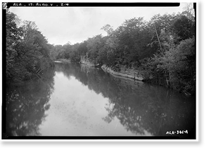
Historic Architecture - Allsboro vicinity, Alabama - Big Bear Creek
Step back in time with this striking reproduction of Big Bear Creek Covered Bridge, Allsboro vicinity, Colbert County, AL - 4. Sourced from the United States Library of Congress.Library of Congress...$57.00 -
 Snapshots of the Past
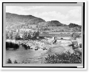
Historic Landscape - Covered Bridges - New Hampshire. Woodport
This rare historical print captures New Hampshire. Woodport. the Connecticut River and covered bridge.Platino in remarkable detail. Sourced directly from the Library of Congress, it represents an...$57.00 -
 Snapshots of the Past
Vintage Americana Print - Brownsville, Pennsylvania - The Covered bridge
Drawn from the Library of Congress archive, this print depicts The Covered bridge, Brownsville, Pa. The Library holds one of the most comprehensive collections of American and international...$57.00